Kashmir faces heightened earthquake risks from active faults, soft soil
Study analyses 12,125 tremors, warns unsafe buildings could magnify disaster
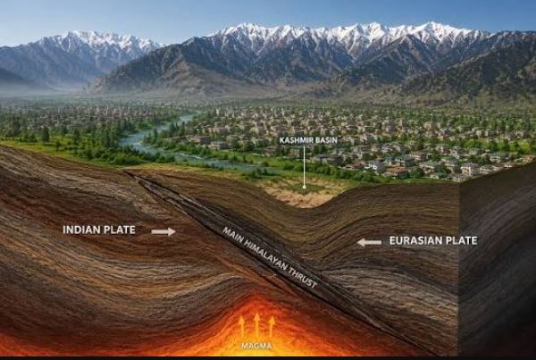
Srinagar: Indian illegally occupied Jammu and Kashmir faces significant earthquake risks as active faults, soft soil and unsafe buildings likely to magnify the impact.
Unplanned urbanisation may further increase casualties and property damage, researchers warned in a scientific study.
The study analysed 12,125 earthquake events recorded across the northwest Himalaya. The records cover the period from 1902 to 2017. Researchers assessed seismic activity and identified geological vulnerabilities. They also examined factors that could worsen earthquake damage.

Titled “Seismic Hazard and Probability Assessment of Kashmir Valley, Northwest Himalaya, India,” the study highlights serious regional risks. It estimates an 88 percent probability of a magnitude 7.7 or stronger earthquake. This probability applies within 50 years across the wider northwest Himalayan region.
The estimated probability rises to 97 percent for magnitude 7.5 or above. It reaches 100 percent for an earthquake of magnitude 6.5 or above. The corresponding statistical recurrence intervals are 47, 27 and four years. Researchers stress these estimates are not earthquake predictions. They do not identify when or where a tremor may strike. These probabilities also do not apply to Kashmir Valley alone.
Active faults and vulnerable ground
Kashmir and the Chenab Valley largely fall in Seismic Zone V. This is the highest category under India’s current seismic classification. The region lies along the active Indian-Eurasian plate boundary.
Researchers identify several fault systems across and around Kashmir. These include Oldham’s Lost Fault and Balapur Fault. Others include Central Kashmir, Mawer and Tunda fault zones. The Gulmarg and Mughal Road fault zones are also identified.
The study highlights the Valley’s soft alluvial and lacustrine deposits. Such deposits can amplify seismic waves and ground shaking. Loose, water-saturated soil also creates liquefaction risks. During strong shaking, soil can lose strength and behave like liquid. This can undermine foundations and threaten building stability.
Groundwater generally lies four to six metres below the surface. In some locations, however, it may be just half a metre deep. Shallow groundwater increases the potential for soil liquefaction. Researchers particularly flag this risk during summer.
The study calls for detailed soil assessments before construction. Alluvial plains, Karewa tablelands, lacustrine plains and wetlands need scrutiny.
Unsafe construction
Researchers warn that unplanned urbanisation compounds geological vulnerabilities. High-rise buildings and unsafe construction could worsen earthquake losses. The decline of traditional building systems is another concern.
These include Taq and Dhajji Dewari construction techniques. Both use timber elements to improve earthquake resistance. Researchers urge safety assessments of homes and public infrastructure. Schools, hospitals, shopping complexes and industrial facilities need scrutiny.
Poor site selection and inadequate construction pose additional risks. A shortage of open spaces and earthquake shelters could hamper rescue operations. The study therefore calls for stricter building standards. It also urges regular structural assessments and public preparedness.
Researchers recommend seismic micro-zonation across the Kashmir Valley. This would map differences in ground conditions and local hazards. The findings should guide land-use planning and building regulations. They should also inform decisions on critical infrastructure.
Kulgam tremor renews focus
The study’s findings come amid renewed attention to regional seismic activity. A 3.6-magnitude earthquake struck south Kashmir’s Kulgam district. It occurred in Damhal Hanjipora at 1:00:46 am on Friday. The National Centre for Seismology recorded its depth at 10 kilometres.
Earth scientist Professor Shakil Ahmad Romshoo described the tremor as a reminder. He said Kashmir’s active tectonic setting makes such earthquakes unsurprising. Its shallow depth made the tremors perceptible in nearby areas.
Romshoo stressed that earthquakes cannot be predicted. Their exact timing, location and magnitude remain unknown. He called preparedness and risk reduction the most effective safeguards.
Riyaz Ahmad Mir, a scientist at the National Institute of Hydrology, also highlighted local faults. He identified the Balapur and Jhelum faults around D.H. Pora. He said southwestern Pir Panjal is also tectonically active.
Mir stressed that earthquake risk varies between locations. Proximity to faults, soil conditions and building vulnerability all matter. He called for detailed fault mapping and seismic micro-zonation. He also urged enforcement of earthquake-resistant building codes. Regular safety drills should be held in schools and public institutions.
The research was authored by Rakesh Chandra, Javid Ahmad Dar, Shakil Ahmad Romshoo, Irfan Rashid, Imtiyaz A. Parvez, Sareer Ahmad Mir and Midhat Fayaz. The Ministry of Earth Sciences supported the research. It involved the University of Kashmir and CSIR Fourth Paradigm Institute.
The researchers emphasise that earthquakes cannot be prevented or precisely predicted. However, safer buildings and informed planning can reduce disaster risks. They urge authorities to prioritise risk assessment and public preparedness.